River Plate

Buenos Aires Port

Geographical Location

Latitude: 34º 36 ' 45 south.
Longitude: 38º 22 ' 03 west.
Terrestrial surface:  4.695.600 M2
Surface Mirror of Water: 1.921.164 M2 

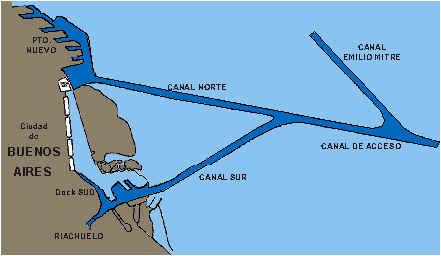
The access to the Port of Buenos Aires is made through a series of 200 km of dredged channels on the bed of the Río de la Plata. These passages that start in the km. 0 and go into Dársena Norte are called:

  • Canal Norte: km. 0.900 to km. 7.300

  • Canal de Acceso (Access Canal): km. 7.300 to km. 37.000

  • Rada Exterior: km. 37.000 to km. 57.000

  • Paso Banco Chico: km. 57.000 to km. 81.000

  • Canal Intermedio: km. 81.000 to km. 121.000

  • Canal Punta Indio: km. 121.000 to km. 201.600

The artificial navigable waterway finishes in km. 205,3000 at the Pontón Prácticos Recalada, a place where the ships take the Práctico of the Río de la Plata up to km.37,000 (Pontón Prácticos Intersección). In that place they are changed, as per the final destination of the ship, the port of Buenos Aires, Dock Sud or the ports on the Paraná River through the Emilio Mitre channel.

The towage to reach the port of Buenos Aires is taken from about km 6,000 of the Access Canal.

The Access Canal to the port is 9.75 meters deep as per local zero, in 100 meters wide and with a 1:8 slope.The maintenance of the navigation of the main waterways from km. 201,600 of Punta Indio canal, to km. 12,000 of Emilio Mitre canal and Paraná river to the port of Santa Fe is made by a private company - licensee - to the passing ships.
Depth Channels of Access

  • Canal Punta Indio: 29 feet half deep.

  • North access: 30/32 feet

  • South access: 30 feet.

Road access
The port of Buenos Aires is connected with the national road system and it is the centre of the road network that links all the commercial centres and cities within the country.
The south of the country is connected by lanes 1,2 and 3. The National Lane number 3 reaches the far south of the country, in the Province of Tierra del Fuego, Antarctica and South Atlantic Islands. National lanes 5 and 7 are connected with the West, Center and North of the country with lanes 8 and 9.

Marine lines:
The traffic and the frequencies are carried out for the four traditional routes:

  • Coast east and south American North, including the Caribbean and Gulf.

  • Europe by Mediterranean.

  • Europe by Atlantic.

  • South Africa and Orient.

The frequency of the services varies according to the routes but on the average they can be counted between 25 and 30 ships with weekly scales in Buenos Aires.

Statistical

In the port of Buenos Aires, the first six months of the year 2000, 3.723.935 tns was manipulated., against 3.820.961 tns. of the same period of the previous year,  that hurtles a drop of 2,5%.

Inside this volume it corresponded for the load general 3.000.906 tns. against 2.836.373 tns. what one means ascends of 5,8% resultant of a decrease of the load in bundles that it reached 39,7% and one ascends of the load of containers of 12%.

The import was of 1.790.627 tns. against 1.903.571 tns. meaning a drop of 5,9% and the export experienced a drop of 0,4% resultant of 1.837.205 tns. against 1.844.816 tns.

In what concerns to containers, always speaking for the first six months of the year, a total of 244.286 units was reached against 228.053 what one represents it ascends of 7,1%. The movement expressed in Teus was of 362.260 against 325.405 with one it ascends of 11,3%.

The movement of ships totalled 873 against 879 what represents a reduction of arrivals of the order of 0,7%. 

General description

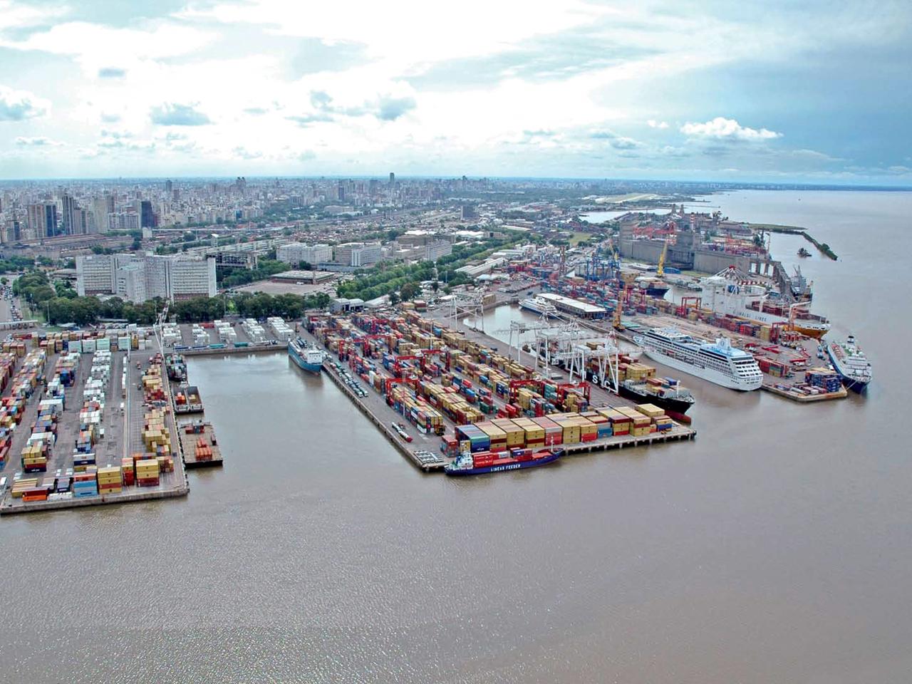
The Port of Buenos Aires is the main port of the country, participating in 40% of the Argentinean external trade being under conditions of increasing that participation.

Through their jetties and private Terminals a superior volume circulates to the 800.000 Teus a year.

The Port of Buenos Aires was divided in three autonomous port administrations:

  • Port Dock South (it passed at the hands of the Pcia. of Buenos Aires)

  • Port South Basin (To the South of Port Madero, until the Riachuelo)

  • New port (To the North of Port Madero)
Infraestructure
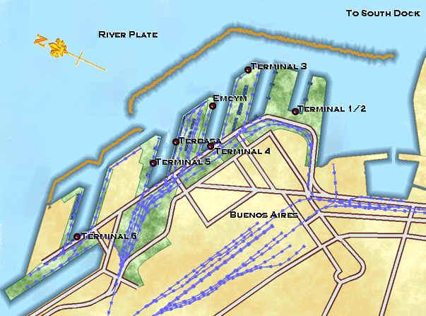
The port of Buenos Aires is divided in five -5- general cargo terminals (Terminal 1/2, Terminal 3, Terminal 4, Terminal 5 and Terminal 6), operated by different licensees who are in charge of all the services to be rendered on cargoes and ships.
It also has a grain terminal with a capacity of 170,000 metric tons, that has also been privatized. This terminal covers a surface of about 8 hectares with a 1040-meter dock and four -4- mooring places.
At present, Terminal 6 is not working and it will be reconverted together with the new areas that will extend the surface of the Port.
The area covered by the five general cargo terminals is about 92 hectares, with 5,600-meter docks and 23 mooring places for ships more than 180 meters long.
The depth at the dock's foot and channel is 9.75 meters regarding local zero, with a river average of +0.80 meters. There have been extraordinary high and low tides that reached +4.44 meters and -3.68 meters, respectively.
The theoretic maximum capacity is 1,200,000 TEUs, and the maximun occupied capacity rise up 818.334 TEUs and 727.969 TEUs in 1998 and 1999.

Begining the year 2000 the port of Buenos Aires had the following equipment:
  • Portainer cranes: 11 units

  • Transtainer cranes: 16 units

  • Mobile cranes: 7 units

  • Portal Cranes for break bulk: 6 units

There will be more equipment at the end of the works that are being performed by each terminal in charge of private companies.
New Port
The call New Port understands 6 basins, 5 of overseas, calls A, B, C, D and E of south to north and one of denominated coastal traffic F. The overseas basins are separated by espigones and they are protected by a jetty in address 350 degrees during the first 1.540 meters. When arriving here, that is to say in front of the third espigón located among the basins D and AND (5to.espigón) traveling this way other a thousand 180 m. In this place the jetty is off (km. 3,2) forming an entrance to New Port for which the crafts that you/they come navigating from the north for the coastal channel can happen. That entrance has 145 m. of wide. Passed this, the continuous jetty in address 305 degrees for 950 m. plus until when arriving at the 6to. espigón forms an elbow of 40 degrees to unite to him. New port is where the Port Terminals are located.

In the year 1993 the Minister of Economy and Works and Public Services - it would Secrete of Transport - (Subsecretaría of Ports and Navigable Roads) threw to National and International Public Bid the Concession of Port Terminals in New Port - Buenos Aires. Soon after they have been created it six port terminals.

Terminal Nº 6 Intefema CORP.
This terminal at the moment is inactive. He/she is summoned in the sixth espigón and it leaves of the recruit, the head of the Basin "E" and the northeast side of the Basin " F ". It occupies an Area of 21 hectares. It has 140 mts. of jetty on the head of the sixth espigón, 585 mts. in the south side its and 496 mts. in the north side of the Basin "E" and 194 mts. plus 25 mts. in the head of this Basin. Totalling 1105 mts. of jetty.

Terminal N° 7 SIMAR CORP.
 
General description
The main property of Marine Integral Services is located in front of Tandanor in the Coastal South. It has an area of 45.000 m2 where deposits are located with 300 m2 dedicated to administrative offices and 500 covered m2 for shop of repairs. Also bill with another additional deposit of 10.000 m2 for the reception and delivery of refrigerating units. It possesses forty connections for containers reefer. A third deposit is located in Park Patricios and it has 25.000 surface m2 and a property covered with 1.400 m2 to carry out repairs in dry. This terminal is specialized in the deposit and treatment of empty containers.

Infrastructure:
Two top loaders of 15 tons. Kalmar Makes Stacking of 5 containers of high, and Beloti Makes Stacking of 4 containers of high. Four trucks Otawa with chassis for containers and automobiles. Two side stacker Kalmar of 12 tons and a Fork lif Hyster of 7 tons and he/she mediates.

Services:
Repair of containers dry low norms IICL. Repair of containers reefer. Control of containers reefer on board the ships. Storage of all type of containers. Logistics. Operation of ships tank in Dock South. Repairs of emergencies inside the country. Operation of import automobiles coming from Uruguay together with Buquebús.

Basin F
This Basin is only used by fluvial ships, those of overseas don't consider access to her for its soaked one. It is located to the West of the Basin "E" and of the Sixth espigón and separated from them for a street. It is formed by two jetties built in address 146°, 326°, the one of out, that is to say the one that is located on the side of the river measures 965 meters long and the one that the file toward the side of the city has 870 meters. The width of the basin is of 220 meters. Their head is formed by two jetties, one of 82,65 meters and the other of 177,90 that form an angle to each other. The entrance mouth to this basin opens up in its western extremity, he/she has a width 210 meters and there are not buoys in her. The access to this basin is carried out by means of a derivation channel that comes off of the Coastal channel. In the jetty located on the side of the river they can operate barges and tugs of the system called to push those that can discharge their products coming from the ports located along the rivers Paraná and Uruguay here. The fluvial ships have their post in this basin, on the jetty that is on the side of the river. Separated by a street of this jetty there are shops, deposits and offices. The jetty located on the side of the city is a piedraplen. On him there are 11 posts of it robs those that bring closer their stern to discharge the snub areneras.
North Basin
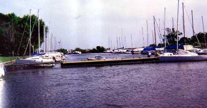
In the entrance to the North Basin is two buoys constituted by square frames of iron, of 3 meters high each a, colored of black and with white light to gleams that of the north. The direct line that unites these two buoys constitutes the denominated kilometer zero, starting from which the distances of the different channels and routes of the River of the Silver are counted. This basin has the form of an irregular quadrilateral in whose oriental side is the entrance 200 width meters that communicates him with the North before port . The two parts in that it is divided by this entered the wall that forms the side This of the basin, measure 210 meters that of the South, 221,30 that of the North. The jetty located in front of the entrance, that is to say the one that forms their side West begins 390 meters long and that of the north 326,03. The south side of the North Basin is constituted by a jetty interrupted by the passage channel that unites to this Basin with the dike 4. The north riverside is occupied by the Naval Post Buenos Aires and for the Naval Shops of North Basin (Tandanor). On him they are two dry dikes. The shops also occupy the north part of the side east, the one that one knows as 4ta. section of the North Basin. Separated from this for the entrance mouth to North Basin is the south part of the side east, a part of which is occupied by the building of the Yacht Argentinean Club. To this part of the North Basin he knows it to him as section 5ta. In her they rob the ships of the Marina of War, frigate Libertad, ships school that visit the port of Buenos Aires etc. In the south side of the North Basin two sections of the Sixth and the Seventh located to both sides of the channel from the passage to the Dike 4 exist. A part of the building located in the Seventh Section is occupied by the Service of Control of Mishaps and fire and for the Service of Salvage and Diving of the Naval Prefecture Argentina the one that has the motobombas and other necessary elements there the possible catastrophes that can take place in the port to combat. Another part is occupied by the section you finish off of the Customs. The jetty of the North Basin 1 have a long of 200 meters and a depth 24 feet being dedicated to general load and containers. That of North Basin 6a, he has 220 meters, the same depth and it is dedicated to the same end.

Roadstead
The North before port measures 735 m. of south at north and 938 of east to west. He/she has an entrance 200 width meters between both jetties and an exit 285 meters. To the posts of it robs the floating dikes they are tied 1, 2 and 3 of TANDANOR.
South Basin
The South Basin is the first part of Port Timber being located in the south end. She has a long of 1. 278 meters in their axis and a width of 242 m. in their mouth near the street Suarez, the one that goes diminishing until the 100 m. in their extremity NO. One enters to the South Basin going by the South before ports. The jetty west of the South Basin is dedicated to the ships that complete regular service to the port of Montevideo. In the same one it operates the company FERRYLINEAS having wide facilities in earth, offices, office, control customs officer etc. Also operates in this area the company Buquebus that completes a service to the Uruguay, leaving North basin. The opposed riverside that is to say the one that is beside the river measures 1. 230 mts. In the jetty of this riverside located to the entrance of the South Basin, they usually tie dredges buoys  and snub. Next he is a small shipyard belonging to the shops of the Naval Prefecture Argentina and then it follows a section assigned to the Shop of Buoys the Service of Naval Hydrography. Continuing toward inside she is another section belonging to YPF with a jetty of 144 provided m of two restitutions so that the ships tanks can discharge derived of petroleum to the deposits located in earth. Continuous then another jetty in which the Casino floating Star of the Fortune whose entrance is made by the Avenue Brazil is, also counting, with a wide place for parking of vehicles. 
Port terminals Nº1 and Nº2

TERMINALS RIVER PLATE
Avda.Ramón Castillo and Comodoro Py
New port - Tel.: (54-11) 4319-9011
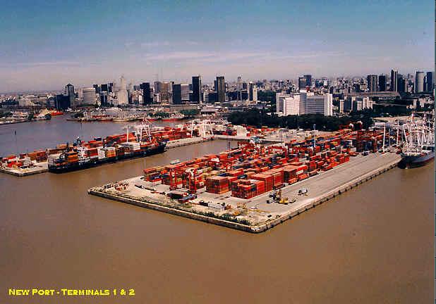
Surface: 28.5 hectares
Dock lenght: 1,813 meters
Mooring Places: 7

Equipment:
  • Portal cranes: 5 units

  • Transtainer cranes: 11 units

  • Railed cranes: 1 unit with a capacity of 35 ton

  • Mobile container cranes: 14 (2 Reach Stackers and 12 Heavy Duty Forklifts)

  • Empty container handlers: 7 units

  • Forklifts: 30 units, capacities ranging between 7 and 2.5 ton

  • Tractors: 22 units

  • Trailers: 23 units

  • Intakes for reefer containers: 120

Terminales Río de la Plata (TRP) is a subsidiary company of London P&O Steam Navigation Company and it is made up of P&O Australia Ltd., a number of Argentine partners.
The company has been given the license to operate Terminals 1 and 2 at Puerto Nuevo, Buenos Aires, for 25 years. The area granted has been completely restructured.
The old warehouses for general cargo and many buildings have been demolished and the area has been paved and equipped with hi-tech machines for the handling of containers, according to international standards.
The area granted to TRP is the largest one, with a projected maximum capacity of 1 million Teus per year, after stage 2 of the works.

DOCKS
Dock 1: two mooring places, 365 meters long, that allow the operation of container ships with a 32-foot depth below them. There are two portal cranes.
Dock 2: two mooring places, 450 meters long, that allow the operation of container ships and a maximum 32-foot depth available. There are three portal cranes.
In addition to the abovementioned, there are places for the operation of ships or feeder barges at a 151-meter dock, 32-foot depth, served by a mobile crane with a capacity of 35 ton.
Finally, and in the case of congestions, there is a sixth place 235 meters long where ships with their own derrick equipment can operate.

CONNECTIONS
Access of trucks: The Terminal has 7 lines of access, 3 of which also serve as ways for the exit of equipment. In the future, there will be two more gates with similar characteristics.
Train: Two railway lines go across the Terminal, near its boundaries. Both have two trails and cross the TRP in different places. TRP receives about 20 trains per month with containerized cargos for their export, from Mar del Plata, Valle del Río Negro and other cities of the hinterland.
Transhipments: the Terminal is familiar with the activities related to transhipments and, at present, each month about 20 barges containing this kind of cargoes are handled.

Port terminal Nº3

TERMINALES PORTUARIAS ARGENTINAS
Av. de los Inmigrantes and Edison s/n
Access Maipú - New Port
Tel.: (54-11) 4317/0600

Surface: 15 hectares
Dock lenght: 1,397 meters
Mooring Places: 6
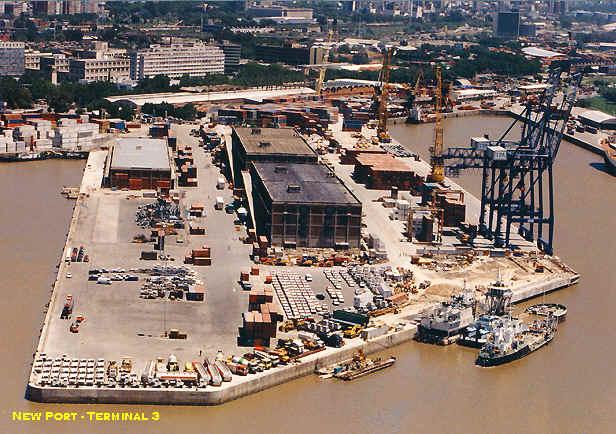
Equipment:

  • Portal cranes: 2 units

  • Transtainer cranes: 2 units

  • Mobile cranes: 2 units

  • Portal cranes for break bulk: 3 units

  • Mobile container cranes: 7 (5 Reach Stackers and 2 top loaders)

  • Forklifts:12 units, capacities ranging between 2.5 and 16 ton

  • Tractors: 12 units

  • Trailers: 20 units

  • Intakes for reefer containers: 120

Terminales Portuarias Argentinas (TPA) is the result of a joint venture among Quatro Invest from Argentina, LANCO from the United States and the International Finance Corporation, member of the World Bank.
Quatro Invest belongs to an Argentine family that manages a road transport company made up of an important fleet of trucks. It also distributes goods and manages a dry container terminal two kilometers far from the Terminal.
LANCO belongs to an American family and it specializes in the manufacture of equipment for container handling and it is one of the most important intermodal operators in its country and in Mexico.
The IFC specializes in financing private companies in the development of projects in certain areas related to industry and services. The IFC has shares in TPA.
The mission of TPA, operator of the only multipurpose terminal of the port of Buenos Aires - Terminal 3 - is to render the best service to owners and clients. This fact is reflected in a maximum effectivity in the operation of ships and gives a solution to the logistics and movement of containers.
In general, the services offered by TPA are related to the operation of container ships, carriers, general cargo and passengers. The Terminal works on ships and cargoes 24 hours a day during the 365 days of the year. In addition, it offers its storage capacity within the port facilities, distribution and loading/unloading of containers of any kind of cargo. The door to door delivery is an example of the way in which TPA meets its clients' requirements.
TPA also manages a Reefer Container Station and it has never received a claim regarding the temperatures of the containers under its custody. The Terminal offers its clients the storage of lots of empty containers in the port facilities, as well as the repair of these units. It can also render other services, such as P.T.L., cleaning, etc.
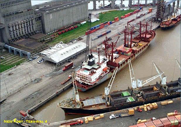
Port terminal Nº4

TERMINAL 4 CORP.
Avda. Ramón S. Castillo and street N° 8
New port - Buenos Aires

Surface: 711 hectares
Dock lenght: 750 meters
Mooring Places: 3/4
Equipment:
  • Mobile cranes: 5 units of different capacities (27 to 300 ton)

  • Mobile container cranes: 6 units with capacities ranging between 7.5 and 42 ton (20 and 40')

  • Motor-driven trimmers: 29 units between 2 and 15 ton

  • Intakes for reefer containers: 100

Terminal 4 is a Multipurpose terminal of integral port services created under the government's privatization plan for Puerto Madero - Puerto Nuevo.
The economic group is also made up of Terminal EMCYM S.A., grain and agricultural by-products elevator, located next to Terminal 4.These companies work together with Angel Gabriel S.R.L, - a transport company - and consolidate their operations so as to strengthen their multimodal services.
The Terminal and its offices are on Darsena C of Puerto Nuevo de Buenos Aires, through Wilson entrance on Avenida Ramón S. Castillo and Calle Nro. 8 (1104)
Terminal 4 consists of more than 11 hectares, 3 / 4 mooring places on 750 meters long, with 32-foot depth. This is the only terminal that keeps within its limits more than 600 meters of railways connected with the dock, thus being allowed to freely operate with the whole national railway system and with three different kinds of trails.
As Terminal 4 operates as multipurpose it not only receives containers but general cargo, grain, by-products and solid bulks as well and it is well-known for its efficiency in the handling of general cargo and, specially, load of projects and big packages.
In order to deal with grain and by-products exports they have a yard for the waiting / classification with an 80-ton electronic scale and the Terminal for the reception/loading itself, with a total storing capacity of about 7,500 meters/ton (grain) and 5,500 meters/ton (by-products). The possible loading speed is 1,000 meters / ton (grain) and 800 meters/ton (by-products) per hour. This terminal operates in a 250 meter-dock and has four 80-ton electronic scales, each one assembled on dumping platforms suitable for trucks - trailers-.
Direct transhipments are made from Terminal 4 to Paraguay, Uruguay and Brazil (Mercosur) and viceversa. Reefer cargoes are controled by a reefer station with capacity for 100 self-sustained containers. This proceeding is supervised by skilled agents who give personalized attention.
The Terminal also has a Logistics Division that separates, stores, administers and transports the importers and exporters' flows of goods up to their distribution in the country.
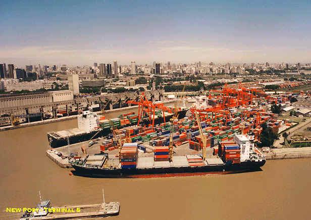
Port terminal Nº5

BACTSSA S.A
Av.Tomás Edison and street 8
New port - Tel.: (54-11)4314-0555
Buenos Aires

Surface: 21.5 hectares
Dock lenght: 885 meters
Mooring Places: 4
Equipment:
  • Portal cranes: 4 units

  • Mobile cranes: 2 units

  • Transtainers: 7 units

  • Side loaders: 4 units

  • Container cranes: 7 units

  • Mobile cranes: 3 units

  • Mobile container cranes: 10 units

  • Intakes for reefer containers

BACTSSA is a joint venture between two international companies: BISA from Argentina and ICTSI from Philippines.
Bemberg Inversiones S.A. is an industrial holding with local and foreign capitals that is involved in different activities, such as the gas distribution, power generation and logistics in Argentina. International Container Terminal Services Inc. is an operator of Manila International Container Terminal (MICT) and controls the 70% of the containerized cargoes from Philippines. It has international operations that include the port of Veracruz (Mexico) and Buenos Aires (Argentina).
BACTSSA, as licensee of Terminal 5, has designed an aggressive development plan which provides for the supply of a wide range of services to shipping companies, maritime agents, exporters and importers.
In addition, BACTSSA is liable for the supply of the latest technology in containers handling in the port of Buenos Aires, as this port concentrates more than the 90% of containerized cargoes in Argentina. The purpose of the company is to put the port of Buenos Aires in the general tendency that imposes the development of traffic with container ships.
The works at the Terminal by the licensee include, at present, an 885 meter-dock with a 31-foot depth, 160,000 square meters for parking areas and handling of containers and 6,500 covered square meters for the storage of goods. BACTSSA has developed a computer system through which not only the loading and unloading operations and the storage of goods can be planned but which allows the clients to get information on-line as well.
Back

River Plate

Buenos Aires Port

Geographical Location

Latitude: 34º 36 ' 45 south.
Longitude: 38º 22 ' 03 west.
Terrestrial surface:  4.695.600 M2
Surface Mirror of Water: 1.921.164 M2 

The access to the Port of Buenos Aires is made through a series of 200 km of dredged channels on the bed of the Río de la Plata. These passages that start in the km. 0 and go into Dársena Norte are called:

  • Canal Norte: km. 0.900 to km. 7.300

  • Canal de Acceso (Access Canal): km. 7.300 to km. 37.000

  • Rada Exterior: km. 37.000 to km. 57.000

  • Paso Banco Chico: km. 57.000 to km. 81.000

  • Canal Intermedio: km. 81.000 to km. 121.000

  • Canal Punta Indio: km. 121.000 to km. 201.600

The artificial navigable waterway finishes in km. 205,3000 at the Pontón Prácticos Recalada, a place where the ships take the Práctico of the Río de la Plata up to km.37,000 (Pontón Prácticos Intersección). In that place they are changed, as per the final destination of the ship, the port of Buenos Aires, Dock Sud or the ports on the Paraná River through the Emilio Mitre channel.

The towage to reach the port of Buenos Aires is taken from about km 6,000 of the Access Canal.

The Access Canal to the port is 9.75 meters deep as per local zero, in 100 meters wide and with a 1:8 slope.The maintenance of the navigation of the main waterways from km. 201,600 of Punta Indio canal, to km. 12,000 of Emilio Mitre canal and Paraná river to the port of Santa Fe is made by a private company - licensee - to the passing ships.

Depth Channels of Access

  • Canal Punta Indio: 29 feet half deep.

  • North access: 30/32 feet

  • South access: 30 feet.

Road access
The port of Buenos Aires is connected with the national road system and it is the centre of the road network that links all the commercial centres and cities within the country.
The south of the country is connected by lanes 1,2 and 3. The National Lane number 3 reaches the far south of the country, in the Province of Tierra del Fuego, Antarctica and South Atlantic Islands. National lanes 5 and 7 are connected with the West, Center and North of the country with lanes 8 and 9.

Marine lines:
The traffic and the frequencies are carried out for the four traditional routes:

  • Coast east and south American North, including the Caribbean and Gulf.

  • Europe by Mediterranean.

  • Europe by Atlantic.

  • South Africa and Orient.

The frequency of the services varies according to the routes but on the average they can be counted between 25 and 30 ships with weekly scales in Buenos Aires.

Statistical

In the port of Buenos Aires, the first six months of the year 2000, 3.723.935 tns was manipulated., against 3.820.961 tns. of the same period of the previous year,  that hurtles a drop of 2,5%.

Inside this volume it corresponded for the load general 3.000.906 tns. against 2.836.373 tns. what one means ascends of 5,8% resultant of a decrease of the load in bundles that it reached 39,7% and one ascends of the load of containers of 12%.

The import was of 1.790.627 tns. against 1.903.571 tns. meaning a drop of 5,9% and the export experienced a drop of 0,4% resultant of 1.837.205 tns. against 1.844.816 tns.

In what concerns to containers, always speaking for the first six months of the year, a total of 244.286 units was reached against 228.053 what one represents it ascends of 7,1%. The movement expressed in Teus was of 362.260 against 325.405 with one it ascends of 11,3%.

The movement of ships totalled 873 against 879 what represents a reduction of arrivals of the order of 0,7%. 

General description

The Port of Buenos Aires is the main port of the country, participating in 40% of the Argentinean external trade being under conditions of increasing that participation.

Through their jetties and private Terminals a superior volume circulates to the 800.000 Teus a year.

The Port of Buenos Aires was divided in three autonomous port administrations:

  • Port Dock South (it passed at the hands of the Pcia. of Buenos Aires)

  • Port South Basin (To the South of Port Madero, until the Riachuelo)

  • New port (To the North of Port Madero)

Infraestructure
The port of Buenos Aires is divided in five -5- general cargo terminals (Terminal 1/2, Terminal 3, Terminal 4, Terminal 5 and Terminal 6), operated by different licensees who are in charge of all the services to be rendered on cargoes and ships.
It also has a grain terminal with a capacity of 170,000 metric tons, that has also been privatized. This terminal covers a surface of about 8 hectares with a 1040-meter dock and four -4- mooring places.
At present, Terminal 6 is not working and it will be reconverted together with the new areas that will extend the surface of the Port.
The area covered by the five general cargo terminals is about 92 hectares, with 5,600-meter docks and 23 mooring places for ships more than 180 meters long.
The depth at the dock's foot and channel is 9.75 meters regarding local zero, with a river average of +0.80 meters. There have been extraordinary high and low tides that reached +4.44 meters and -3.68 meters, respectively.
The theoretic maximum capacity is 1,200,000 TEUs, and the maximun occupied capacity rise up 818.334 TEUs and 727.969 TEUs in 1998 and 1999.

Begining the year 2000 the port of Buenos Aires had the following equipment:
  • Portainer cranes: 11 units

  • Transtainer cranes: 16 units

  • Mobile cranes: 7 units

  • Portal Cranes for break bulk: 6 units

There will be more equipment at the end of the works that are being performed by each terminal in charge of private companies.
New Port
The call New Port understands 6 basins, 5 of overseas, calls A, B, C, D and E of south to north and one of denominated coastal traffic F. The overseas basins are separated by espigones and they are protected by a jetty in address 350 degrees during the first 1.540 meters. When arriving here, that is to say in front of the third espigón located among the basins D and AND (5to.espigón) traveling this way other a thousand 180 m. In this place the jetty is off (km. 3,2) forming an entrance to New Port for which the crafts that you/they come navigating from the north for the coastal channel can happen. That entrance has 145 m. of wide. Passed this, the continuous jetty in address 305 degrees for 950 m. plus until when arriving at the 6to. espigón forms an elbow of 40 degrees to unite to him. New port is where the Port Terminals are located.

In the year 1993 the Minister of Economy and Works and Public Services - it would Secrete of Transport - (Subsecretaría of Ports and Navigable Roads) threw to National and International Public Bid the Concession of Port Terminals in New Port - Buenos Aires. Soon after they have been created it six port terminals.

Terminal Nº 6 Intefema CORP.
This terminal at the moment is inactive. He/she is summoned in the sixth espigón and it leaves of the recruit, the head of the Basin "E" and the northeast side of the Basin " F ". It occupies an Area of 21 hectares. It has 140 mts. of jetty on the head of the sixth espigón, 585 mts. in the south side its and 496 mts. in the north side of the Basin "E" and 194 mts. plus 25 mts. in the head of this Basin. Totalling 1105 mts. of jetty.

Terminal N° 7 SIMAR CORP.
 
General description
The main property of Marine Integral Services is located in front of Tandanor in the Coastal South. It has an area of 45.000 m2 where deposits are located with 300 m2 dedicated to administrative offices and 500 covered m2 for shop of repairs. Also bill with another additional deposit of 10.000 m2 for the reception and delivery of refrigerating units. It possesses forty connections for containers reefer. A third deposit is located in Park Patricios and it has 25.000 surface m2 and a property covered with 1.400 m2 to carry out repairs in dry. This terminal is specialized in the deposit and treatment of empty containers.

Infrastructure:
Two top loaders of 15 tons. Kalmar Makes Stacking of 5 containers of high, and Beloti Makes Stacking of 4 containers of high. Four trucks Otawa with chassis for containers and automobiles. Two side stacker Kalmar of 12 tons and a Fork lif Hyster of 7 tons and he/she mediates.

Services:
Repair of containers dry low norms IICL. Repair of containers reefer. Control of containers reefer on board the ships. Storage of all type of containers. Logistics. Operation of ships tank in Dock South. Repairs of emergencies inside the country. Operation of import automobiles coming from Uruguay together with Buquebús.

Basin F
This Basin is only used by fluvial ships, those of overseas don't consider access to her for its soaked one. It is located to the West of the Basin "E" and of the Sixth espigón and separated from them for a street. It is formed by two jetties built in address 146°, 326°, the one of out, that is to say the one that is located on the side of the river measures 965 meters long and the one that the file toward the side of the city has 870 meters. The width of the basin is of 220 meters. Their head is formed by two jetties, one of 82,65 meters and the other of 177,90 that form an angle to each other. The entrance mouth to this basin opens up in its western extremity, he/she has a width 210 meters and there are not buoys in her. The access to this basin is carried out by means of a derivation channel that comes off of the Coastal channel. In the jetty located on the side of the river they can operate barges and tugs of the system called to push those that can discharge their products coming from the ports located along the rivers Paraná and Uruguay here. The fluvial ships have their post in this basin, on the jetty that is on the side of the river. Separated by a street of this jetty there are shops, deposits and offices. The jetty located on the side of the city is a piedraplen. On him there are 11 posts of it robs those that bring closer their stern to discharge the snub areneras.
North Basin
In the entrance to the North Basin is two buoys constituted by square frames of iron, of 3 meters high each a, colored of black and with white light to gleams that of the north. The direct line that unites these two buoys constitutes the denominated kilometer zero, starting from which the distances of the different channels and routes of the River of the Silver are counted. This basin has the form of an irregular quadrilateral in whose oriental side is the entrance 200 width meters that communicates him with the North before port . The two parts in that it is divided by this entered the wall that forms the side This of the basin, measure 210 meters that of the South, 221,30 that of the North. The jetty located in front of the entrance, that is to say the one that forms their side West begins 390 meters long and that of the north 326,03. The south side of the North Basin is constituted by a jetty interrupted by the passage channel that unites to this Basin with the dike 4. The north riverside is occupied by the Naval Post Buenos Aires and for the Naval Shops of North Basin (Tandanor). On him they are two dry dikes. The shops also occupy the north part of the side east, the one that one knows as 4ta. section of the North Basin. Separated from this for the entrance mouth to North Basin is the south part of the side east, a part of which is occupied by the building of the Yacht Argentinean Club. To this part of the North Basin he knows it to him as section 5ta. In her they rob the ships of the Marina of War, frigate Libertad, ships school that visit the port of Buenos Aires etc. In the south side of the North Basin two sections of the Sixth and the Seventh located to both sides of the channel from the passage to the Dike 4 exist. A part of the building located in the Seventh Section is occupied by the Service of Control of Mishaps and fire and for the Service of Salvage and Diving of the Naval Prefecture Argentina the one that has the motobombas and other necessary elements there the possible catastrophes that can take place in the port to combat. Another part is occupied by the section you finish off of the Customs. The jetty of the North Basin 1 have a long of 200 meters and a depth 24 feet being dedicated to general load and containers. That of North Basin 6a, he has 220 meters, the same depth and it is dedicated to the same end.

Roadstead
The North before port measures 735 m. of south at north and 938 of east to west. He/she has an entrance 200 width meters between both jetties and an exit 285 meters. To the posts of it robs the floating dikes they are tied 1, 2 and 3 of TANDANOR.
South Basin
The South Basin is the first part of Port Timber being located in the south end. She has a long of 1. 278 meters in their axis and a width of 242 m. in their mouth near the street Suarez, the one that goes diminishing until the 100 m. in their extremity NO. One enters to the South Basin going by the South before ports. The jetty west of the South Basin is dedicated to the ships that complete regular service to the port of Montevideo. In the same one it operates the company FERRYLINEAS having wide facilities in earth, offices, office, control customs officer etc. Also operates in this area the company Buquebus that completes a service to the Uruguay, leaving North basin. The opposed riverside that is to say the one that is beside the river measures 1. 230 mts. In the jetty of this riverside located to the entrance of the South Basin, they usually tie dredges buoys  and snub. Next he is a small shipyard belonging to the shops of the Naval Prefecture Argentina and then it follows a section assigned to the Shop of Buoys the Service of Naval Hydrography. Continuing toward inside she is another section belonging to YPF with a jetty of 144 provided m of two restitutions so that the ships tanks can discharge derived of petroleum to the deposits located in earth. Continuous then another jetty in which the Casino floating Star of the Fortune whose entrance is made by the Avenue Brazil is, also counting, with a wide place for parking of vehicles. 
Port terminals Nº1 and Nº2

TERMINALS RIVER PLATE
Avda.Ramón Castillo and Comodoro Py
New port - Tel.: (54-11) 4319-9011

Surface: 28.5 hectares
Dock lenght: 1,813 meters
Mooring Places: 7

Equipment:
  • Portal cranes: 5 units

  • Transtainer cranes: 11 units

  • Railed cranes: 1 unit with a capacity of 35 ton

  • Mobile container cranes: 14 (2 Reach Stackers and 12 Heavy Duty Forklifts)

  • Empty container handlers: 7 units

  • Forklifts: 30 units, capacities ranging between 7 and 2.5 ton

  • Tractors: 22 units

  • Trailers: 23 units

  • Intakes for reefer containers: 120

Terminales Río de la Plata (TRP) is a subsidiary company of London P&O Steam Navigation Company and it is made up of P&O Australia Ltd., a number of Argentine partners.
The company has been given the license to operate Terminals 1 and 2 at Puerto Nuevo, Buenos Aires, for 25 years. The area granted has been completely restructured.
The old warehouses for general cargo and many buildings have been demolished and the area has been paved and equipped with hi-tech machines for the handling of containers, according to international standards.
The area granted to TRP is the largest one, with a projected maximum capacity of 1 million Teus per year, after stage 2 of the works.

DOCKS
Dock 1: two mooring places, 365 meters long, that allow the operation of container ships with a 32-foot depth below them. There are two portal cranes.
Dock 2: two mooring places, 450 meters long, that allow the operation of container ships and a maximum 32-foot depth available. There are three portal cranes.
In addition to the abovementioned, there are places for the operation of ships or feeder barges at a 151-meter dock, 32-foot depth, served by a mobile crane with a capacity of 35 ton.
Finally, and in the case of congestions, there is a sixth place 235 meters long where ships with their own derrick equipment can operate.

CONNECTIONS
Access of trucks: The Terminal has 7 lines of access, 3 of which also serve as ways for the exit of equipment. In the future, there will be two more gates with similar characteristics.
Train: Two railway lines go across the Terminal, near its boundaries. Both have two trails and cross the TRP in different places. TRP receives about 20 trains per month with containerized cargos for their export, from Mar del Plata, Valle del Río Negro and other cities of the hinterland.
Transhipments: the Terminal is familiar with the activities related to transhipments and, at present, each month about 20 barges containing this kind of cargoes are handled.

Port terminal Nº3

TERMINALES PORTUARIAS ARGENTINAS
Av. de los Inmigrantes and Edison s/n
Access Maipú - New Port
Tel.: (54-11) 4317/0600

Surface: 15 hectares
Dock lenght: 1,397 meters
Mooring Places: 6

Equipment:

  • Portal cranes: 2 units

  • Transtainer cranes: 2 units

  • Mobile cranes: 2 units

  • Portal cranes for break bulk: 3 units

  • Mobile container cranes: 7 (5 Reach Stackers and 2 top loaders)

  • Forklifts:12 units, capacities ranging between 2.5 and 16 ton

  • Tractors: 12 units

  • Trailers: 20 units

  • Intakes for reefer containers: 120

Terminales Portuarias Argentinas (TPA) is the result of a joint venture among Quatro Invest from Argentina, LANCO from the United States and the International Finance Corporation, member of the World Bank.
Quatro Invest belongs to an Argentine family that manages a road transport company made up of an important fleet of trucks. It also distributes goods and manages a dry container terminal two kilometers far from the Terminal.
LANCO belongs to an American family and it specializes in the manufacture of equipment for container handling and it is one of the most important intermodal operators in its country and in Mexico.
The IFC specializes in financing private companies in the development of projects in certain areas related to industry and services. The IFC has shares in TPA.
The mission of TPA, operator of the only multipurpose terminal of the port of Buenos Aires - Terminal 3 - is to render the best service to owners and clients. This fact is reflected in a maximum effectivity in the operation of ships and gives a solution to the logistics and movement of containers.
In general, the services offered by TPA are related to the operation of container ships, carriers, general cargo and passengers. The Terminal works on ships and cargoes 24 hours a day during the 365 days of the year. In addition, it offers its storage capacity within the port facilities, distribution and loading/unloading of containers of any kind of cargo. The door to door delivery is an example of the way in which TPA meets its clients' requirements.
TPA also manages a Reefer Container Station and it has never received a claim regarding the temperatures of the containers under its custody. The Terminal offers its clients the storage of lots of empty containers in the port facilities, as well as the repair of these units. It can also render other services, such as P.T.L., cleaning, etc.
Port terminal Nº4

TERMINAL 4 CORP.
Avda. Ramón S. Castillo and street N° 8
New port - Buenos Aires

Surface: 711 hectares
Dock lenght: 750 meters
Mooring Places: 3/4
Equipment:
  • Mobile cranes: 5 units of different capacities (27 to 300 ton)

  • Mobile container cranes: 6 units with capacities ranging between 7.5 and 42 ton (20 and 40')

  • Motor-driven trimmers: 29 units between 2 and 15 ton

  • Intakes for reefer containers: 100

Terminal 4 is a Multipurpose terminal of integral port services created under the government's privatization plan for Puerto Madero - Puerto Nuevo.
The economic group is also made up of Terminal EMCYM S.A., grain and agricultural by-products elevator, located next to Terminal 4.These companies work together with Angel Gabriel S.R.L, - a transport company - and consolidate their operations so as to strengthen their multimodal services.
The Terminal and its offices are on Darsena C of Puerto Nuevo de Buenos Aires, through Wilson entrance on Avenida Ramón S. Castillo and Calle Nro. 8 (1104)
Terminal 4 consists of more than 11 hectares, 3 / 4 mooring places on 750 meters long, with 32-foot depth. This is the only terminal that keeps within its limits more than 600 meters of railways connected with the dock, thus being allowed to freely operate with the whole national railway system and with three different kinds of trails.
As Terminal 4 operates as multipurpose it not only receives containers but general cargo, grain, by-products and solid bulks as well and it is well-known for its efficiency in the handling of general cargo and, specially, load of projects and big packages.
In order to deal with grain and by-products exports they have a yard for the waiting / classification with an 80-ton electronic scale and the Terminal for the reception/loading itself, with a total storing capacity of about 7,500 meters/ton (grain) and 5,500 meters/ton (by-products). The possible loading speed is 1,000 meters / ton (grain) and 800 meters/ton (by-products) per hour. This terminal operates in a 250 meter-dock and has four 80-ton electronic scales, each one assembled on dumping platforms suitable for trucks - trailers-.
Direct transhipments are made from Terminal 4 to Paraguay, Uruguay and Brazil (Mercosur) and viceversa. Reefer cargoes are controled by a reefer station with capacity for 100 self-sustained containers. This proceeding is supervised by skilled agents who give personalized attention.
The Terminal also has a Logistics Division that separates, stores, administers and transports the importers and exporters' flows of goods up to their distribution in the country.
Port terminal Nº5

BACTSSA S.A
Av.Tomás Edison and street 8
New port - Tel.: (54-11)4314-0555
Buenos Aires

Surface: 21.5 hectares
Dock lenght: 885 meters
Mooring Places: 4
Equipment:
  • Portal cranes: 4 units

  • Mobile cranes: 2 units

  • Transtainers: 7 units

  • Side loaders: 4 units

  • Container cranes: 7 units

  • Mobile cranes: 3 units

  • Mobile container cranes: 10 units

  • Intakes for reefer containers

BACTSSA is a joint venture between two international companies: BISA from Argentina and ICTSI from Philippines.
Bemberg Inversiones S.A. is an industrial holding with local and foreign capitals that is involved in different activities, such as the gas distribution, power generation and logistics in Argentina. International Container Terminal Services Inc. is an operator of Manila International Container Terminal (MICT) and controls the 70% of the containerized cargoes from Philippines. It has international operations that include the port of Veracruz (Mexico) and Buenos Aires (Argentina).
BACTSSA, as licensee of Terminal 5, has designed an aggressive development plan which provides for the supply of a wide range of services to shipping companies, maritime agents, exporters and importers.
In addition, BACTSSA is liable for the supply of the latest technology in containers handling in the port of Buenos Aires, as this port concentrates more than the 90% of containerized cargoes in Argentina. The purpose of the company is to put the port of Buenos Aires in the general tendency that imposes the development of traffic with container ships.
The works at the Terminal by the licensee include, at present, an 885 meter-dock with a 31-foot depth, 160,000 square meters for parking areas and handling of containers and 6,500 covered square meters for the storage of goods. BACTSSA has developed a computer system through which not only the loading and unloading operations and the storage of goods can be planned but which allows the clients to get information on-line as well.

Back